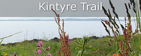
Tarbert - Southend | Kintyre Trail
This easy to follow and delightful trail captures the unique history and beauty of Kintyre, relaxing you and introducing you to a dramatic trail following in the footsteps of Norse and Scottish legend.
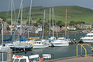
Tarbert
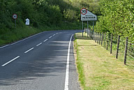
The trail begins at Tarbert, Kintyres most northerly point. One of the few natural harbours of Scotland overlooked by Robert the Bruces hilltop castle is home to the second biggest yachting event in the United Kingdom. Tarbert is home to an important fishing fleet and port for a ferry to Portavadie. The tourist information office in Tarbert can provide information about life in the area and things to do or see. Pick up a copy of the Kintyre Trail brochure and map at the Tourist Information Office in Harbour Street, tarbert.
Skipness
Continuing on the trail either spending the rest of the day on a long, pleasant walk through beautiful landscapes or by road, the next stop is Skipness renowned for its 13th Centruy castle which stands proud in excellent condition, drawing many visitors year after year. A chapel dedicated to St Brendan stands nearby also from the 13th Century.
Claonaig
If you are planning to go to Arran then this is where the ferry to Arran departs from during the summer months. Just after Claonaig is some picturesque forestry walks and a parking place, a quaint spot to have some lunch or a cup of tea before setting off a few miles down the road to the next destination on the trail map.
Grogport
There are some beautiful places along the east coastal road ( B842 ) and Grogport is no exception. With beautiful forestry all on one side and sandy beaches and clean waters on another, this often quiet secluded spot can be great for a picnic or a lazy afternoon. There is good fishing waters running nearby and again some lovely walks to enjoy the sunshine and the rest of the family's company. Why not stop and go and see the Organic Tannery at work here.
Carradale
Heading south along the picturesque coastal country road, the trail continues on to Carradale, a busy fishing village popular as a holiday destination for families and couples. Carradale is at the centre of a whole network of coastal walks and forest walks teaming with deer, birds and the odd shy adder. The stretch of coast holds pleasant beaches and coves worthy of exploration and it has been known to see basking sharks surface feeding in shallow waters.
Torrisdale
The pleasant drive continues south from carradale, the road from here becomes somewhat quicker than the slower road before, again you pass some real beautiful countryside. The cycle route runs alongside this road and runs by the sea. Passing through the small Torrisdale village you then continue a few miles along the road to Saddell.
Saddell
Next stop along this long winding road is Saddelll. Here you will find Saddell Abbey, founded by Somerlad in 1160 and completed by Reginald, his son.You can see grave slabs here that have Celtic Stone carvings here, depicting monks, knights, salmon, ships, otters, salmon and other images. The castle here at Saddell was built in 1508, by the Bishop of Argyll using much of the stone from the old Abbey. Here you can experience the small pleasant walk down to Saddell Bay. You will find a delightful little beach here and again, a lovely place to stop for a picnic. Behind Port na Gael , is Pluck Wood with mature beech trees and native woodlands. On the summit of the hill within this woodland overlooking Saddell Bay is the remains of an Iron Age fort dating from before 500BC.
If you carry on 3 miles towards the next destination on the trail to Campbeltown you come to a more impressive Kildonan Galleried Dun fort dating from around 200AD which was excavated between 1936 and 1939 producing which are now at Campbeltown Museum. There is parking available near by this impressive sight.
Peninver
Peninver is a tiny linear village tht you will pass through as you go to Campbeltown, here you will find a lovely campsite on the shores of its own private beach, some lovely coastal scenery, and here in the modern town hall, is where various dancing events are held throughout the year.
Campbeltown
The largest town in Kintyre, Campbeltown with an approximate population of 7000, is the next stop on this trail. As you would expect from this town there is quite a few shops to visit, a museum and a heritage centre.
Once home to a big fishing fleet before the herring stocks diminished to lower levels, Campbeltown also had no fewer than 34 whisky distilleries. There is some lovely architecture here and something for all the family. With a small single screen cinema, a picturesque harbour and a thriving community spirit despite hardships, visit Campbeltown and take a look in the Heritage Centre for more information at life in this town.
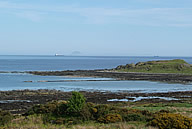
Davaar Island
Connected to the mainland by a tidal breakwater, Davaar Island is deserted all but a lighthouse to the north made famous by a large cave painting of the crucufixion which appeared there in 1887 under mysterious circumstances. It is definitely a place worth visiting but it is stressed that you MUST know the tide times as once you are caught across unawares you will have to wait until the next low tide to arrive before you return across, so be warned.
If walking is your thing and you fancy a safer trek with a view, then south-west of Davaar Island is the hills of Bienn Ghuilean, where you can enjoy more walks through terrific woodland and rise upon hilltops to take in the special views associated with the "Wee Toon".
Southend
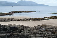
Following the coastal road along the southern tip of Kintyre brings you to Southend, the road here is narrow and winding and will take a little longer than the quicker B842 directly from Campbeltown. Southend lies on the shores of Kintyre with a attractive sandy beach with unusual rock formations and rock clours protruding from the sands. Opposite from this beach is a car park where you can stop and go to see the famous footprints where St Columba first preached here in Scotland and also St Kiaran's Cave where an old stone table and water basin can be seen. If you are a keen golfer there is a gorgeous and very well kept 18 hole links golf course here alongside the ruins of Dunaverty Castle, there is only a little left of this castle and it is difficult to find and is best to ask a local of its whereabouts. There was a brutal massacre at this site in 1647 of 300 of Sir Alasdair MacDonald's army after surrendering during a seige, a castle which they had owned since the 7th Century.
Mull Of Kintyre
Onwards from Southend along the coastal road for a short distance you will arrive at the Mull Of Kintyre, brought to everyones attention by Paul McCartney's hit record. When you have parked your car, you can walk the short distance to the lighthouse at the very tip, where it has stood since 1788 warning the ships away from the dangerous rocky coast here at the Mull. There is a cairn here to remember the mysterious Chinook helicopter disaster that occurred here. Plenty of time may be needed but it is possible to walk along the coast atop the hills to Machrihanish passing Balmavicar, a ruined township. If you are a keen ornithologist, the walk can provide you with sights of great birds such as the rare golden eagle. The views here are spectacular and on a good day, you can see Ireland clearly unaided.
Machrihanish
Once again, golfers will be pleased to visit here as has a classic championship links golf course. The 1st hole is renowned as being the World's greatest opening hole as endorsed by Jack Nicklaus. Machrihanish was the centre of thriving coal working from the 18th century until 1967 as has Kintyre's only coal mine here. More recently Machrihanish RAF base was used strategically by American forces who pulled out a few years ago taking away some of the crucial economy of the local area, civilian planes however run from the public airfield that is at the base. Travelling northwards you will find Argyll's biggest mainland sand beach which stretches for some 6 miles, a polpular place for surfers and windsurfers alike, with many the "white horses" crashing on a windy day. At the northern most point of this beach are some excellent and fun dunes that will keep your children occupied for hours.
Bellochantuy
Travelling northwards after your windsurf or sand dune climbing the old and charming village of Bellochantuy which also has a lovely beach, stretching for some distance. The original Gaelic "Bealach an t-sith" means The Fairies' Pass and is one of the most difficult place names to say. The best mainland views of Islay can be found here and some of the most beautiful sunsets can be found here on a perfect summer evening.
Glenbarr
The main road passes by the village of Glenbarr but if you take the time to travel through the village, Glenbarr Abbey awaits, which is in fact a mansion house, home to the Clan Macalister. It has some truly amazing interiors and contains a small museum of family memorabilia, is definitely worth a visit. It is also worth carrying on driving as far as the narrow road will take you to see some strange cup-and-ring markings on several outcrops that may be of interest to the keen archeologist thought to dat from the Bronze Age. Slightly further inland and of interest to keen walkers, is the highest hill in Kintyre, Beinn an Turc (454m).
Muasdale
Travelling north with the hills of Jura firmly in view out to the West, you approach the little west coast village of Muasdale, its name derived from the Norse "mangus-dalr", meaning, the valley of the monks. The village has a small caravan park and a quaint village store, and some attractive coastline. This pleasant little village is a welcome view on your journey northwards.
Killean
The next stop that isnt on the official trail, nevertheless deserves mention, quite rightly for its tourist features. Three miles north of Muasdale before you reach Tayinloan is the estate village of Killean, of which Killean House stands unseen in trees above. Nearby at Beacharr, the tallest standing stone in Kintyre towers at just over 5 metres, an amazing 16 feet. Beside this is a Neolithic chambered cairn where the first Neolithic pottery was recognised, the original pottery from this chamber cairn is in the Campbeltown Museum. Also here is previously the most important parish church in Kintyre standing on the left side of the road as you travel northwards, even due to damage by ivy and through pillaging of ths stone, there is some superb detail remaining here to see.
Tayinloan
Only a short mile north of Killean is Tayinloan, it is here that the car and passenger ferry departs to the beautiful Gigha, translated from the Norse meaning "God's Island", a visit here is a must for any tourist. Tayinloan is a fine little village with an old inn and a general store selling confectionary, small toys and many foods and drinks.
Ronachan
Ronachan Point is not a village, but a popular stopping place and viewing point along the west coast of Kintyre. With a small car park at the side of the road and a board with information on, it is a small but worthy stop off. You will find here an dun ruin dating from the Iron age as you walk to the shore front, where on a summers day you will see seals basking on the rocks protruding through the waters surface, and sometimes these inquisitive creatures will swim in to find out more about you. Also in the woods above Ronachan House is an earlier Iron Age fort of a different type and different date.
Clachan
Further north is Clachan, this delightful old village has an unusual church which you can see as you round the corner at the bottom of the north approaching hill. Overlooking the village of Clachan, 2 miles north of Ronachan, there is another Iron Age site, which has three forts on the same hilltop with much more present than the two other sites at Ronachan. Here at Dun Skeig along the farm track you will also fing along with the Iron Age relics, the marvellous views of West Loch Tarbert and Islay and Jura.
Whitehouse
Back on the trail now only a short stretch from Tarbert where you began, you pass through the delightful little village of Whitehouse, there may not be a fort here, or a museum or such like, but the village itself deserves a worthy mention and more than just a passing glance at the immaculate white cottages that will remind you of eras gone by, and days of the horses pulling carts along dirt tracks passed these graceful old buildings.
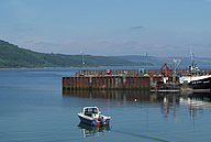
Kennacraig
Here at Kennacraig is the concrete causeway leading to the ferry terminal that transports locals and tourists across to the beautiful islands of Islay and Jura. As with Gigha, a trip to Kintyre is incomplete without a visit to these western isles, again take plenty of time but just make sure you have enough information about the isles and that you know the extact ferry times.
Trail Complete
The tourist trail of Kintyre is now complete, however there is so many other features, nooks and crannies that are not mentioned that are still there to explore, there are beaches to find, and something for you to discover for yourselves. Enjoy the walks and explore to your hearts content.
This trail is not the easiest tourist trail to follow, although it is difficult to get lost on any of the roads, it is sometimes difficult to find those monuments or attractions that you so desperately want to see. If you have prepared yourself gaining as much information from the tourist office, and have given yourself plenty of time you should find it a delightful journey and one that you will want to do again, and if you do have a problem finding something, the people of Kintyre are both friendly and very helpful and I am sure if they are asked nicely, they will delight in helping you find that hidden treasure.
Tarbert is both an excellent place to stay and start you trail. Then once you have seen all there is to see in Kintyre and the associated isles, you can then reach out and discover what the rest of Argyll can offer, and you will always be welcomed back to Tarbert, to enjoy the best of what is on offer at this beautiful "Gateway To Kintyre".